
The Kekekabic Trail Run Report
- alexanderfalconer
- Oct 20, 2019
- 7 min read
Updated: Oct 22, 2019
For this run we camped at Trails End USFS campground the night before. Nobody else was in the campground and we have the feeling it was shut down for the winter…but facilities were still open and stocked with toilet paper, no roads blocked and we did see another car roaming around – unsure if they were camping or just passing through. It is a wonderful campground we first discovered as we had to portage through part of it at the end of our Sag – Seagull loop on this summer’s BWCA canoe trip. Cold evening: 31 as a low. Camp was set up, we ate pasta in the car, and snuggled in to extra bedding and blankets in the tent.

Woke up around 4:30 am to get coffee and oatmeal cooking, change into running clothes and do a final gear check for the pack I was going to be running with. I also made a game day decision to go without the water bladder since the tube and nozzle would freeze and I didn’t want to fuss with refilling the bladder from a stream with cold fingers. Traded that out for a standard 1L Nalgene. We got to the trail head around 6 am, took pictures and a final good luck – “see you on the other side” set of hugs and kisses from Erica and the kiddos.


The beginning:
For the first hour or so it was mostly dark, the light of day coming from behind as I headed west running away from the sun. The trail for the first couple miles runs along Mine Lake and rivers/streams that until recently covered a lot of the trail. The Kek association has done a great job rerouting the trail up the hillside a bit where possible though it wasn’t more than a mile or so that my feet were already wet. It was a slow moving first couple miles and the light was up by the time I made it to the Wilderness border – roughly 2.6 miles in.


The weather:

It was cold. But cold is fine and easy to deal with – just need layers and extras to swap out to get dry again. Earlier in the week rain was in the forecast and rain at 35 degrees is a recipe for hypothermia, of which I am not a fan. Thankfully as the forecast started to solidify the temp dropped a bit and rain turned to snow and it was game on! It snowed intermittently the entire day. The temp was always above freezing after the sun came up, probably bouncing between 33 – 35 degrees so the snow didn’t stick and made for some wet leaves to crash through and slippery rocks but that’s workable. But this is Minnesota and we run when it snows. Onward!
The leaves!
October is absolutely magic in Minnesota. After daylight and entering the Wilderness border the trail climbed up to the first vantage point offering views from above of the surrounding wilderness hills, lakes, streams and wetlands.


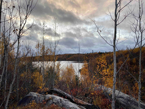
Even though I was running a little bit past peak leaf season the golds of the aspen and birches and tamaracks were still a bright golden yellow against the darkly contrasting deep greens of the evergreens. The beginning portion and the end had the highest overlooking sections compared to the lower section in the middle that had some hills but was more along lakeside and streams.
The trail:

From reading the Kek Association site and trail update, I was pretty optimistic about the state of the trail. They’ve put in some serious effort these past couple years in particular getting the trail into shape.
Like I mentioned in “The beginning” section this trail is a pretty wet trail. As a trail runner, this makes it difficult to get any real momentum going for long periods when the trail is consistently interrupted by streams, beaver dams (which gets it’s own section), marshes etc. There were only two or three real sections of climbing (compared to the adjoining Border Route Trail, this is the main contrast) up to vantage points. The majority of the Kek was in valleys between hills, or slightly up on hillsides where the lakes are swollen from precipitation or established beaver dams.
Traveling through the forest like this though offers a great chance to really get a feel of the territory and to be a direct witness to the interconnectedness of the waters. Each lake steps down to the next lake, streams with rapids generally connecting the two. The forest floor this time of year is gorgeous with a rainbow of fallen leaves everywhere – red and orange maples, darker red or purple sumac, yellow birch and aspen leaves and the greens of mosses and younger pine trees as the backdrop against the brighter colors.

The entire trail is interrupted by streams which are passable only over logs placed across or rocks that can be hopped on. In some cases you just have to grin and bear it and stomp through the water. And in many cases, five I think but maybe more, because I lost count, the “bridge” across streams are actual beaver dams you have to walk over. And sometimes the water spilling over the dam means you get to walk through that muck as well. In plenty of other places, at least this time of year with lots of recent rainfall, the trail is just flooded and it’s either splash through or bushwhack around.


The last 5 miles or so of trail (Snowbank Lake side) travel through the 1999 blowdown area – where a storm of straight line winds decimated roughly 500,000 acres toppling an estimated 20 million trees. This storm was the largest and strongest in modern history and 20 years later it’s still evident. However also 20 years later the forest is rebounding with new trees now filling in the gaps left by blown over trees – balsam fir, black spruce and white cedar jump starting the regrowth.
The beaver dams:

I lost count along the way, but I’ll say 5 – there were 5 (give or take) where the “bridge” across the streams crossing the trail were the beaver dams themselves. I was completely dumbfounded the first time I came across this scenario, totally unsure where to go with the top of the dam apparently as the only choice. The Kek association had their blue tape up from recent clearing trips that helped confirm my suspicions. This is quintessential Boundary Waters Wilderness travel. The Superior Hiking Trail has some beaver dam bridges here and there as well, as I discovered during this year's Superior 100, but since it isn’t wilderness, they are also at least supplemented with some boardwalks for support. Not here – no choice but to carefully climb on top of and carefully walk along the ridge – sometimes through water running over down the stream (again with the wet feet) until solid ground on the other side presented itself.

The moose!

There’s a bull moose known to live near Seahorse Lake and we were fortunate enough to meet each other. His lady friend crossed the trail first and I heard her loud crash and stopped suddenly to see what was up. I could barely make her out through the brush and then heard a very loud crashing coming from behind her. It was like something out of Lost – seeing the treetops waving back and forth, unable to see the smoke monster but knowing something was coming. He finally emerged as I waited for him (I had a large tree to the right that would serve as my block if he charged – safety first!) to come out. We stood about 25 feet from one another and pensively stared at each other assessing the situation. At some point I clearly wasn’t a danger and he ate some maple leaves in front of him, crossed the path and in the direction of the female who crossed first.
I of course couldn’t just let that be it so tried to quietly scramble through the bush to the lake edge but definitely made too much noise and scared the cow off, the bull following suit. They ran together along the lake edge and back into the woods across the bay. The scene was gorgeous with the golden aspens and birches, green trees, yellow grasses and the two giant animals lumbering alongside the lake and into the woods.
The water!
Potentially the best part of running for miles and miles and miles lies in the name of this place: Boundary Waters Canoe Area Wilderness. There is so much water here. The Superior National Forest is home to 20% of the fresh water in the entire National Forest System. And, in the Boundary Waters, where no human development or engines are allowed, the water is still so pristine you can drink straight from the lake. No joke – no filter! Logistically this makes things easier for the run – don’t have to carry 40 miles worth of water on me from the beginning, no added weight or bulk from a filter, and can pretty much refill whenever I get to a big enough body of water or stream between lakes!
The end:

I finished at 11 hours and 53 minutes! Came into the western trailhead at Snowbank Lake before dark. If I had one goal other than finishing, it was just to finish before dark – and I did! The last couple minutes were a race against the rotation of the earth. Also because of conflicting info out there I didn’t know if I had 5 miles to go or 2 miles to go as I left the Wilderness border. My GPS tracked me at 39.6 miles – just under 40. The Kek Association says it’s 41 and the Forest Service says the trail is 44 miles. Either way I finished and the first data for this route is up on the Fastest Known Time website with my gpx file showing the route. I really hope this notoriety on that site as well as promotion of this run itself compels others to run and track their route as well. Maybe with a few more data samples we’ll be able to hone in on an exact length.
The run is now the first recorded Trailrun of the Kek on the Fastest Known Time site. I have no doubts others have through hiked it, maybe run it, but I'm hoping with it now on the FKT site more people will be drawn to run this Wilderness gem of a trail.
Well, if you've read this far - thanks!! And please remember I’m running these Boundary Waters Wilderness trails as my way to bring attention to the sulfide-ore mining proposals that threaten this beautiful place. It’s absolutely reprehensible all this water and wilderness should be put at risk forever from the short term financial gain of a Chilean billionaire with no care for what happens to American public lands. Trail runners - stand up and shout out. Get active and keep our public lands and waters safe now and for future generations!
🏃♂️🏕🛶⛰🌲🏃♂️ 🏃♂️ 🏃♂️ 🏃♂️


Comments